EURIALO – Safe Aviation Ensured From Space

The EURIALO civilian space system will be designed for continuous, global and independent air traffic monitoring, and will thus significantly enhance airspace safety once constructed.

An airplane.

An airplane. Image credit: Tobias Rehbein via Pixabay, free licence

The goal of the future EURIALO space system is to increase international air traffic safety. Small satellites will be used to monitor all commercial flights continuously and globally.

The European Space Agency (ESA) has awarded the contract for the development of an initial test system to the company Spire Global Germany GmbH, based in Munich.

“EURIALO is an ideal way to utilise the technological potential offered by space technology for aviation,” says Fabienne Spreen, EURIALO project manager at the German Space Agency at the German Aerospace Center (Deutsches Zentrum für Luft- und Raumfahrt; DLR).

“In the future, a constellation of small satellites will enable the precise determination of aircraft locations in real time.”

In the future, the EURIALO civilian space system will be able to monitor air traffic across the globe and around the clock and thus contribute to improving airspace safety. It operates independently of Global Navigation Satellite Systems (GNSS).

In the future, the EURIALO civilian space system will be able to monitor air traffic across the globe and around the clock and thus contribute to improving airspace safety. It operates independently of Global Navigation Satellite Systems (GNSS). Image credit: ESA

Following the signing of the contract, work will now begin on the development of an initial test system. It will consist of four small satellites in low-Earth orbit (LEO) and a ground segment for data processing and distribution.

Combining two independent systems ensures safety

In order to reliably locate an aircraft in the sky, its position data is recorded using two independent systems. By combining and cross-referencing the data in both systems, potential errors can be eliminated. The first system relies on a signal transmitted by the aircraft itself. Using Global Navigation Satellite Systems (GNSS), the aircraft can accurately determine its own location.

The second system involves ground-based air traffic control radar systems. These systems can only operate within a confined radius and cannot adequately cover remote regions or the airspace over oceans. Consequently, locating and monitoring aircraft becomes challenging in such areas.

The satellite constellation and ground segment of the EURIALO system

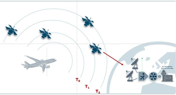
The satellite constellation and ground segment of the EURIALO system. Image credit: ESA

Continuous flight tracking from space

The long-term goal of EURIALO is to fill the gaps in traditional ground-based tracking through satellite-based monitoring.

A fleet of small satellites will operate with global coverage, receiving the radio signals that aircraft already emit automatically and at regular intervals when transmitting data to ground stations. From low-Earth orbit, these satellites will use their antenna systems to continuously receive these signals and track the aircraft.

When several satellites receive the same signal from an aircraft, the intersection point will be calculated using a technique called ‘multilateration’ in order to reliably determine its position, independently of GNSS.

To transmit these data in real time, the satellites must communicate with each other directly or via relay stations. These intersatellite links (ISL), enable constant contact between all the satellites in the constellation and the ground stations. By complementing terrestrial radar surveillance, the system aims to significantly improve air traffic safety.

Source: DLR